


VTD - precinct 12, Perkins County, South Dakota
About
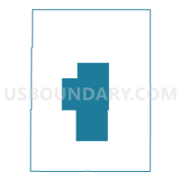
Outline

Summary
| Unique Area Identifier | 667727 |
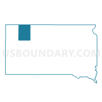
| Name | VTD - precinct 12 |
| County | Perkins County |
| State | South Dakota |
| Area (square miles) | 430.80 |
| Land Area (square miles) | 428.06 |
| Water Area (square miles) | 2.74 |
| % of Land Area | 99.36 |
| % of Water Area | 0.64 |
| Latitude of the Internal Point | 45.43777080 |
| Longtitude of the Internal Point | -102.48674520 |
Maps

Graphs
Select a template below for downloading or customizing gragh for VTD - precinct 12, Perkins County, South Dakota


Neighbors
Neighoring Voting District (by Name) Neighboring Voting District on the Map
- VTD - precinct 6, Perkins County, SD
- VTD - precinct 7, Perkins County, SD
- VTD - precinct 8, Perkins County, SD
- VTD - precinct 9, Perkins County, SD
- VTD-precinct 2, Perkins County, SD
- VTD-precinct 4, Perkins County, SD
- VTD-precinct 5, Perkins County, SD
Top 10 Neighboring County Subdivision (by Population) Neighboring County Subdivision on the Map
- Bison town, Perkins County, SD (333)
- South Perkins UT, Perkins County, SD (176)
- Northeast Perkins UT, Perkins County, SD (101)
- Strool township, Perkins County, SD (51)
- Meadow township, Perkins County, SD (48)
- Rainbow township, Perkins County, SD (42)
- Chance township, Perkins County, SD (40)
- Marshfield township, Perkins County, SD (30)
- Scotch Cap township, Perkins County, SD (29)
- Bison township, Perkins County, SD (24)
Top 10 Neighboring Place (by Population) Neighboring Place on the Map
Top 10 Neighboring Unified School District (by Population) Neighboring Unified School District on the Map
- Lemmon School District 52-4, SD (2,124)
- Bison School District 52-1, SD (912)
- Faith School District 46-2, SD (809)